Monday, September 15, 2014

Delhi most polluted city in the world : WHO


According to WHO, one-eighth of the total deaths in the world is caused by air pollution — both indoor and outdoor
According to WHO, one-eighth of the total deaths in the world is caused by air pollution — both indoor and outdoor.
Delhi is the most polluted city in the world, says a study released by World Health Organisation (WHO) on Wednesday.
The 2014 report of the Ambient Air Pollution (AAP) database contains results of outdoor air pollution monitoring from almost 1600 cities in 91 countries.
The national capital has the highest concentration of PM2.5 — particulate matters less than 2.5 microns– form of air pollution, which is considered most serious and can cause respiratory diseases and other health problems.
The situation is so bad in Delhi that its air has PM2.5 concentrations of 153 micrograms and PM10 concentrations of 286 micrograms–much more than the permissible limits, says the WHO.
In comparison, Beijing, which was once considered one of the most polluted cities, has PM2.5 concentration of 56 micrograms and PM10 concentration of 121 micro grammes.
Air quality is represented by annual mean concentration of fine particulate matter (PM10 and PM2.5,– particles smaller than 10 or 2.5 microns).
The database covers the period from 2008 to 2013, with the majority of values for the years 2011 and 2012.
Reacting to the report, Anumita Roychowdhury of the Centre for Science and Environment (CSE) said the new WHO data base only confirms the health concerns in India.
“According to global burden of disease estimates, air pollution is the fifth largest killer in India. Tiny particles (PM10 and PM2.5) go deep inside our lungs and trigger respiratory and cardiac problems as well as lung cancer,” said Anumita.
WHO said that in most cities air pollution is getting worse.
“Many factors contribute to this increase, including reliance on fossil fuels such as coal fired power plants, dependence on private transport motor vehicles, inefficient use of energy in buildings, and the use of biomass for cooking and heating,” it said.

source:: http://indianexpress.com/article/cities/delhi/delhi-most-polluted-city-in-the-world-who/

Sunday, September 14, 2014

Tonnes of e-waste pile up in IT hub, pose grave health and eco-hazard

GURGAON: A rapidly growing Gurgaon — IT and communications hub of North India — is today at the cusp of a possible environmental crisis which may be triggered by modern technology. Electronic waste is a byproduct of technological advancement that has become a health concern in all urban centres of the world. And Gurgaon, where the IT industry is central to the economy, is certainly no exception. 

In recent days, some new e-waste recycling units, licensed and approved by the pollution control board, have come up in the city. But this hasn't ensured that e-waste gets in the right hands. According to S John Robert, CEO of Earth Sense, which is a recycling unit located in Manesar, the highest proportion of e-waste generated here still goes to the 'informal sector,' comprising scrap dealers and illegal sellers. 

"The volume of e-waste that the authorized sector gets has gone down even from last year. The informal sector still gets the most amount of e-waste, where it is illegally sold," Robert said. 

Scrap dealers are usually after valuable and saleable metals commonly found in e-waste components. Then, the remaining bits are usually disposed of in an improper way — these are often dumped in a water body or burnt, causing toxic elements to mix with the air or drinking water, thus creating a health hazard. 

"The main reason for this state of affairs is a lack of policy framework to deal with e-waste, and lax enforcement on the part of pollution authorities," said Viresh Malik, a senior IT professional. 

According to a recent report on the danger posed by the rapidly rising piles of e-waste in major cities, Gurgaon generates a whopping 12,000 metric tonnes of e-waste every year, which is second only to the volume generated annually in Delhi, and is the highest among all towns in the NCR. Given the fact that Delhi is more than thrice as large as Gurgaon, and its population over ten times as much as that of the Millennium City, these figures are striking indeed. 

The e-waste study, released on Thursday by the Associated Chambers of Commerce and Industry of India, also projects an annual hike of 25% in the e-waste generation figures across the NCR. This means that by the year 2017, the total generated volume of e-waste in the whole of Delhi-NCR - which is now around 55,000 metric tonnes (MT) — will reach the 95,000 MT mark, with Gurgaon being a major contributor to this figure. 

"Less than 2% of the total e-waste generated in this country gets properly recycled. And this is mainly due to absence of proper infrastructure, legislation and framework," said D S Rawat, secretary general of Assocham.

SOURCE:: http://timesofindia.indiatimes.com/city/gurgaon/Tonnes-of-e-waste-pile-up-in-IT-hub-pose-grave-health-and-eco-hazard/articleshow/39844679.cms

Hydropower: Will new committee break new ground?

Environment and Forests, Government of India (MoEF) announced the constitution of an expert committee to "make a detailed study as to whether hydroelectric power projects existing and under construction in the river basins of Alaknanda, Bhagirathi and their tributaries have contributed to environmental degradation and, if so, to what extent and also whether they have contributed to the tragedy that occurred at Uttarakhand in the month of June, 2013."
The importance of the committee cannot be underestimated as both the issues it is mandated to look at have widespread and long-term implications for all the Himalayan states.
A crying need
As is known, the Government of India and the Himalayan states of the country are on a spree as far as building dams and hydropower projects is concerned. For states like Arunachal Pradesh, Himachal Pradesh, Uttarakhand and J&K, with their perennial snow-fed rivers, steep slopes and fast moving waters, hydropower appears to be a dream resource. Arunachal alone is estimated to have a potential for 50,000 MW of hydropower, if not more.
Visions of huge revenues are driving plans for construction of hundreds of dams and hydropower plants in these states, with cascades of multiple dams planned or already under construction on almost each and every river. Unfortunately, all this has a serious impact on the ecology, environment, livelihoods and social life of the people, which is largely being ignored.
Undoubtedly, there is a requisite process of Environmental Impact Assessment (EIA) and Environmental Clearance for most of these projects. However, the processes are highly ineffective with shoddy EIAs, very limited involvement of local communities (including people directly affected), a clearance system that is deeply flawed and designed to clear every project after deliberately playing down and ignoring negative impacts, and a virtual absence of any compliance monitoring and follow-up. Moreover, while individual projects are at least expected to be examined for such impacts, there is no place for a study of the cumulative impacts of all proposed and existing dams taken together.
In this backdrop, the constitution of an expert committee that will examine whether such projects . existing and under construction . have degraded the environment, and to what extent, is sorely needed.
The second issue that the committee has to examine is also critical. The floods in the third week of June in Uttarakhand have been amongst the most devastating tragedies in the country. While there was an underlying natural calamity - the cloudburst and heavy rainfall - there is little doubt that the intensity of the impact was aggravated many fold due to human intervention in the basin, particularly, as noted by many observers, the flurry of dam and hydropower plant construction and related activities.

Overall, the construction of dams has therefore undoubtedly exacerbated the impact of the natural disaster. As the preliminary report (Brief Report on Uttarakhand Disaster (16/17 June 2013)) by the National Institute of Disaster Management or NIDM, Delhi, prepared by Dr. Surya Parkash, Associate Professor states, "The area has been denuded to a great extent due to deforestation and tree cutting for road construction, building construction, mining, hydel projects etc. It has also resulted in increased surface flow and rise of river bed due to disposal of debris into the rivers ... Thus, the natural terrain conditions combined with climatic / weather conditions and haphazard human intervention made a conducive environment for such a hazardous process to take place in this valley."
It is not only that these dams and plants have blocked and impeded the river flow and distorted the flow channels. These have also called for large scale blasting and digging of tunnels in the fragile mountains. They have dumped massive quantities of muck and debris in the riverbed and surroundings and also aggravated the process of deforestation. Even the impact of road building . which can considerably disturb the delicate balance of the mountain terrain . have been intensified by dams and hydropower, as such projects inevitably require bigger and heavy-duty roads for carrying heavy machinery, as compared to roads necessary for the ordinary needs of local people.
Given the above, the importance of an independent and detailed study of how dam construction has made the area vulnerable cannot be overstated. The study by this expert committee could have far-reaching implications for Uttarakhand and also for other states that are witnessing a spurt in dam construction and hydropower projects.

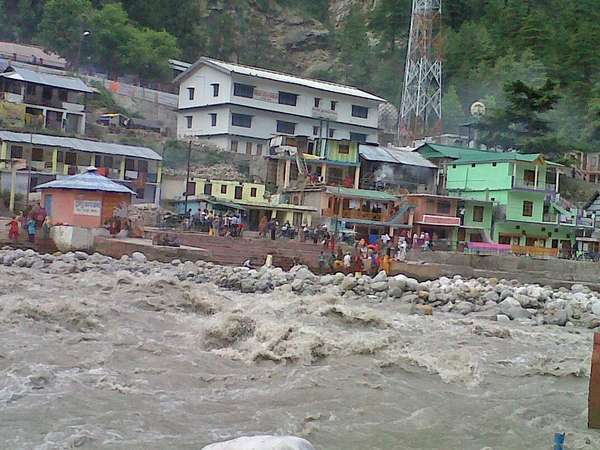
Devastating floods in Uttarakhand wash away everything. Photo courtesy: Sharada Prasad/Citizen Matters
MoEF under pressure
The unfortunate part, however, is that the MoEF has not constituted the committee out of any internally perceived need to reflect and review the impact of its decisions (clearing so many projects in the region) or to assess the real impact of these dams in areas prone to natural disasters. Indeed, the MoEF has been mostly silent and unresponsive to the criticism that dam and hydropower building aggravated the disaster in the state and hence the programme needed a re-look. In reality, the MoEF was pushed to constitute the committee by an Order from the Supreme Court.
On 13 August 2013, the Supreme Court delivered its judgement on the case Alaknanda Hydro Power Co. Ltd Versus Anuj Joshi & Ors. The case dealt with the 330 MW Srinagar Hydroelectric Project which is under construction on the Alaknanda river in Uttarakhand. The project, which obtained various clearances in the mid-1980s, has had a chequered trajectory and the case essentially deals with that. That part of the judgement, which has for all purposes allowed the project to go ahead as it is, is beyond the scope of this discussion but in dispensing its judgment, the Court raises some broader and very relevant concerns.
"Court's Concern"
This section of the Judgement is titled "Court's Concern" and starts with the Court saying: "We are, however, very much concerned with the mushrooming of large number of hydroelectric projects in the State of Uttarakhand and its impact on Alaknanda and Bhagirathi river basins ... The cumulative impact of those project components like dams, tunnels, blasting, power-house, muck disposal, mining, deforestation etc. on eco-system, is yet to be scientifically examined."
It then takes a detailed look at various studies done on these dams, including a study by the AHEC, IIT Roorkee on the cumulative impact assessment of hydropower projects in the Alaknanda and Bhagirathi basin, a study by the Wildlife Institute of India (WII) of the cumulative impacts on aquatic and terrestrial biodiversity and the report of an Inter-Ministerial Group (IMG). This IMG had been set up to look at several issues and suggest environmental flow requirements for the Alaknanda and Bhagirathi and other tributaries, and to review the two cumulative impact studies referred to above.
Lest this plethora of committees and studies should lead one to think that cumulative impact issues are being looked into in the case of the Alaknanda and Bhagirathi basin, it should be clarified that these studies were initiated following continuous pressure from activists and local communities involving protests, long fasts, mass action, and continuous monitoring of the MoEF and other decision-making bodies. Because these studies were not proactive initiatives resulting from genuine concern or intent of the MoEF, they often proved to be substandard. Indeed, the IIT Roorkee and IMG studies have come under sharp criticism from a host of independent experts.
Significantly, the Supreme Court, in its judgement, has also noted that: "... prima facie, we are of the view that the AHEC Report has not made any in-depth study on the cumulative impact of all project components like construction of dams, tunnels, blasting, power-house, muck disposal, mining, deforestation etc. by the various projects in question and its consequences on Alaknanda as well as Bhagirathi river basins so also on Ganga which is a pristine river".
This problem with the quality of the AHEC study and the serious impact noted by the WII and other studies led the Supreme Court to direct the MoEF to constitute the expert committee to re-examine these issues. While this direction is welcome and very important, it would have been useful if the Supreme Court had issued orders for a fresh cumulative impact assessment to be carried out, given that it itself found the AHEC study lacking in depth.
That the Supreme Court perceives the issue to be very serious is also clear from the fact that it has directed both the MoEF and the state of Uttarakhand not to grant any further clearances for any hydropower project in the state till further orders. Whether the MoEF attaches the same kind of importance to the issue is of course a different question. While the Court had ordered that the report be submitted in three months, the MoEF has in fact taken two months just to set up the committee.
How effective will the report be?
One notable feature of the committee is that it is chaired not by a government official but by a civil society representative, namely Prof. Ravi Chopra. Well known social worker and leader Chandi Prasad Bhatt is the Co-Chair of the committee. It also has several other civil society representatives. Despite their involvement, however, there are serious concerns about the committee.
As Himanshu Thakkar of the South Asia Network on Dams, Rivers and People, who has been closely monitoring the developments in the Ganga basin, says even as he welcomes the formation of the committee: "The committee is unwieldy with excessive inclusion of government members and members with conflict of interest. This raises doubts if the committee will be allowed to function in an independent way."
The conflict of interest refers to the presence of B.P. Das in the expert committee. Das has been the vice-chair of the MoEF's Expert Appraisal Committee (EAC) on hydropower projects. The EAC appraises and recommends river valley and hydropower projects for clearances. Thus, in this committee, Das will be sitting to review the environmental impacts of many of the projects that he himself has cleared. It is thus clearly a situation that reflects a conflict of interest.
Apart from overcoming all these issues, the biggest challenge for the committee will be to meet the expectations that people are likely to have. Government committees often end up obfuscating or brushing under the carpet serious issues and presenting ambivalent positions. As this committee is headed by non-official, civil society representatives, people will expect it to go beyond what a government committee normally does and come out with clear and unambiguous stands warranted by the situation. They will rely on it to recommend, without hesitation, any stringent actions that may be necessary.
Lastly, a real concern is whether the MoEF will have the political will to implement these recommendations even if the committee does its part of the job. The track record of the MoEF so far does not inspire much hope.
A recent example is eloquent enough: The MoEF set up a committee to recommend ways to conserve the Western Ghats, in particular by designating sections of it as eco-sensitive zones. The committee was headed by eminent ecologist Madhav Gadgil, and he presented a report that laid out a framework that was an important break from the past, helping conserve the environment but also taking care of concerns of local development. The MoEF found it difficult to implement this framework, and so set up another committee to suggest ways to implement the Gadgil Committee report; this new committee ended up presenting its own framework that significantly diluted what the Gadgil Committee said. (Read more atthis link).
However, given that the case under discussion is being monitored by the Supreme Court, one hopes for a better chance for the report of the expert committee on Alaknanda and Bhagirathi basins to be implemented.

source::http://indiatogether.org/damspower-environment

Reviving the Ganga, at the cost of its ecology!

A new era of development seems ready to take off as the new Ministry of Water Resources, River Development and Ganga Rejuvenation is here. So, we now have barrages planned every 100 km along the Ganga waterway, from Allahabad to Haldia and 11 terminals along the river bank. This will definitely be helpful for transportation of coal and other raw materials to industries along the Ganga, but its ecological impact is yet to be assessed.
While most scientists and seers across the country have been advocating for ‘Aviral Ganga’ (continuous Ganga) over the last decade, the Rs 6,300-crore plan is something which will definitely disappoint them. More pertinent than their disappointment, however, is the question whether the 6300 crores of public funds are being spent fruitfully towards achieving a desirable end.
What if the project is discovered to be unfeasible a few years down the lane? What if it takes a heavier toll than we have even imagined? Such questions merit attention for there are several ecological considerations which need to be factored in, in a project such as this but which have not been considered at all. One of these is that of ecological flow.
Ecological flow refers to the minimum flow of water in our rivers and streams that are necessary to maintain healthy aquatic ecosystems and keep the natural condition of river ecology unspoilt. For that to happen, two things are of utmost importance - sufficient water and enough flow.
Competitive Use
There are 784 dams situated in the Ganga basin (out of which 158 are included in the National Register of Large Dams), 66 barrages, 92 weir and 45 lift schemes. The water resource assets, especially the dams, in the Ganga basin are used for varied purposes such as irrigation, water supply, hydro-electric projects, and drinking water, with 92.83 per cent of total assets being used for the first, which is irrigation.
The average water resource potential of Ganga at present is 525,020 Million Cubic Metre (1 cubic metre=1000 litres) but only 250,000 MCM is utilisable water resource according to the Ministry of Water Resources. Of this available utilisable water, 56,451 MCM is already sanctioned for various hydel projects on the basin. That leaves 193549 MCM of utilisable water in the Ganga.
Out of this, a significant amount of water is being diverted for various industrial purposes, of which there is no reliable account. The Ganga river basin covers 11 states. In UP, Bihar and West Bengal alone, there are thermal power plants with a combined capacity of approximately 50,000 MW, which can be estimated to draw at least 1500 MCM of water from the Ganga Basin.
With several new thermal power plants proposed in the basin, the demand for water by these projects will definitely create a serious water crisis and disparity in the basin. If we take into account the areas of Jharkhand, Madhya Pradesh, Uttarakhand and other states falling in the basin, the total amount of water being extracted from the Ganga basin will add up to a mammoth figure.
Did the new Ministry consider the existing uses of water in Ganga basin and future competitive uses of the waters of the Ganga while drawing up its plan? This is also particularly significant as the water in the middle and lower Ganga is mainly the water from its tributaries like Ghaghra, Yamuna, Chambal, Son, Kosi, Gandak and several others. Will these facts be considered by the Joint Committee?
River Ganga at Naarghat, Mirzapur. Mirzapur is a district between Allahabad and Varanasi, where the River Ganga meets the Vindhyan range. Photo: Debadityo Sinha
Lean Season
The second fact, which very few policymakers consider is the ‘lean season’ of a river. There is a specific restriction on withdrawing water from any river during its lean season. For Ganga, the lean season is from December to May, according to government records. It is due to this reason that extraction of water from the river basin happens mostly between the months of July-October and in a big way. The waters are then stored in local reservoirs in most of the regions for later use.
A question naturally arises here on the scientific expertise available to the Ministry that can help sustain the waterway during the lean season, while maintaining the ecology of the river. Will these barrages ensure the ecological flow of the river during these seasons or will they just maintain enough water levels for ships to move?
Biodiversity
Little attention has been paid to the impact on the wildlife of the Ganga. Gangetic Dolphins inhabit the stretch of the river from Allahabad to Howrah. 50 km of the Ganga in Bhagalpur is protected as ‘Vikramshila Wildlife Sanctuary’, which is unfortunately the only protected habitat in the Ganga for the Gangetic Dolphins, the national aquatic animal of India.
Several kilometres upstream, in Varanasi, a 6-km stretch from Ramnagar Fort to Assi Ghat is also protected as a turtle sanctuary. Not only is this stretch the last habitat of several aquatic animals, it is also ecologically very critical for the free movement of dolphins, an animal protected under Wildlife (Protection) Act, 1972 as Schedule I.
Use of motor boats and sand mining is prohibited in these protected stretches as turtles lay eggs in the sand of river banks and dolphins are affected by noise. However, it is quite clear that the dream project of Transport Minister Nitin Gadkari cannot be a success without affecting these two aquatic wildlife sanctuaries. So will he propose displacement of these animals to some other river?  
If environmental norms are relaxed to make way for the project, the impact on the river and its unique ecosystem will be undeniable. In view of that, it will be interesting to see what the Ministry’s decision on these two protected areas will be and the consequent wildlife management plan that it comes up with.
Cumulative Impact Assessment
The Ganga should not be seen merely as a water resource but as a river that has a deep association with the values and psyche of the people. The entire Ganga basin - with its tributaries, biodiversity, dependent communities and varied competitive uses of river water - should be viewed as a single holistic unit, and the effect of any alteration of the natural course of the river should be considered carefully in terms of its impacts on each of these. A Cumulative Impact Assessment of the entire River Basin should thus be the first step before any policy decisions on the Ganga.
As environmentalists know, a river is often able to clean its pollution itself and there is no need for overt plans and policies as long as sufficient water and its flow are ensured. Due to excessive use and pollution, the Ganga is in a diseased state today and it needs free flow and intensive care. If we do not allow it to heal and continue to over exploit it, it will lead to the death of the river, which is often hailed as the holy mother of the nation.
Do we want our next generation to read about the Ganga only in mythology? That might well be the case if the Joint Ministry Committee does not take note of the ecological concerns surrounding the Ganga waterway.
source:: http://indiatogether.org/ganga-river-waterway-reviving-and-impact-on-ecology-environment

Saturday, September 13, 2014

KASHMIR FLOODS 2014

In September 2014, the Kashmir region was hit by heavy floods from torrential monsoon rains. The regions of Jammu and Kashmir in India, as well as of September  13 th2014, nearly 200 people in India and 205  have died due to the floods. According to theHome Ministry of India, several thousand villages across the state have been hit and 350 villages have been submerged. So far 1,60,000 people have been rescued, including 87,000 from Srinagar city.
Many parts of Srinagar, including the B.S.F H.Q in santnagar & Army cantonment in Badamibagh, were inundated, and vital roads were submerged, by the floods.

The Jammu and Kashmir state and adjoining areas received heavy rainfall from 2 September 2014 onwards, during last stage of monsoon in India. This has triggered flooding and landslides in India and the adjoining areas . On 5 September, the Jhelum River in Srinagarwas reported to flow at 22.40 feet (6.83 m) which is 4.40 feet (1.34 m) above the danger mark and at 33 feet (10 m) at Sangam in Anantnag district which is 12 feet (3.7 m) above the danger mark.
The Chenab River was also reported to flow above the danger mark by which hundreds of villages were affected
In September 2014, Kashmir Valley witnessed disastrous floods across majority of its districts. The death toll as of September 10 has crossed 190 in Kashmir valley and 2600 villages were reported to be affected in Jammu and Kashmir, out of which 390 villages in Kashmir are completely submerged. 1225 villages are partially affected and 1000 villages are affected in Jammu Division The cause of the flood is continuous heavy rainfall due to which local rivers broke out into the streets. The areas affected by the flood are mostly districts in south kashmir which include AnantnagAwantipora and Pulwama.River Jhelum, flows above danger mark in these areas. The discharge rate in the river was recorded as 70000 m3/s against the normal discharge of 25000 m3/s. At least 200 deaths recorded.
As of September 13, in many parts of Srinagar's neighbourhood, the water was about 12 feet (3.7 m) deep, submerging entire houses. Stranded residents left their homes to move in with friends or relatives in safer areas.
In Srinagar, most of the city areas are submerged under water. The river Jhelum spilled over submerging Rajbagh, Jawahar Nagar, Gogji Bagh and Wazir Bagh neighbourhoods of city. The first story of the houses and hotels in Rajbagh that are packed with tourists are submerged. According to the Omar Abdullah, the Chief Minister of Jammu and Kashmir, boats had been brought from Delhi to help with evacuations, and the air force has begun rescue operations in the city.[
50 bridges are being reported to have been damaged across the state. The final assessment of the damaged property can be estimated only after the flood waters recede. The state government is also urging the central government for 25,000 tents and 40,000 blankets for the affected people.[10]
In the Jammu Division, landslides triggered by heavy rainfall have damaged roads, dozens of bridges, buildings and crops. Vehicular traffic has been stopped on the Jammu-Pathankot highway. Katra-bound trains have been halted. Haj flights scheduled up to 12 September, have been postponed.[19] The Jammu-Pathankot national highway was opened on September 8, after the water level receded.Srinagar-Leh Highway reopened for traffic on 9 September.[21] The Prime Minister of India Narendra Modi called it a "national calamity"
Home Secretary of India Anil Goswami said 82 aircraft and helicopters, 10 battalions ofBorder Security Force 329 columns of Indian Army and 300 boats were in the rescue operations. According to home secretary, 10 VSAT systems are being air lifted to restore critical telecom towers and a satellite link from Bardula has been provided for crucial communication.Two IL 76,One CJ 130 and one AN 44 aircraft carried a total of 2000 tonnes of supplies including food, water and medicines. 500 boats were dispatched to South Kashmir for excavation of people from submerged areas.[12] Armed Forces including Border Security Force (B.S.F) and National Disaster Response Force (NDRF) so far rescued 1,60,000 persons in different regions of Jammu and Kashmir.The Indian Armed Forces have done a tremendous job in relief and rescue operations. Bharat Sanchar Nigam Limited(BSNL) has launched an operation on a war-footing with Indian Army and Indian Air Force(IAF) to restore mobile services through satellite network and the telecom network.
Home Ministry has been set to Srinagar to monitor rescue operations. The government has also set up a control room in Delhi and has asked people to approach it with details of their trapped families.

source:: wikipedia


Tuesday, July 9, 2013

ASSAM LIFE BADLY AFFECTED

 Authorities have sounded evacuation alert in Assam, where 11 districts have been badly hit by flood conditions after torrential rains caused River Brahmaputra and its tributaries swell. Nearly one lakh people have been hit by the flood. The Brahmaputra was flowing above the danger mark in districts like Jorhat, Sibsagar, Dibrugarh and Sonitpur. Three hundred and fifty villages in 11 districts were reportedly inundated by the overflowing rivers with Dhemaji district being the worst hit. Sources in Assam State Disaster Management Authority said the district was submerged by the swollen up Jiadhol river. Tinsukia, Golaghat, Nagon, Chirang, Jorhat, Karimganj, Lakhimpur, Morigaon, Kamrup and Sibsagar were also badly hit. Around 900 relief camps have been set up, most of them in Dhemaji district. Wildlife was also affected as flood water entered Kaziranga National Park and Pobitora Wildlife Sanctuary. The former, known for its one-horned rhinoceros, has been partially submerged. Agriculture was also affected as about 6,000 hectares were flooded with standing crops like rice being ruined.

SOURCE::::

Read more at: http://news.oneindia.in/2013/07/09/assam-foods-people-wildlife-agriculture-badly-affected-1255339.html

ASSAM FLOOD WORSENS


Assam's flood situation remained critical today with 11 districts reeling under the water of the swollen Brahmaputra and its tributaries affecting over one lakh people.
Heavy rainfall in the catchment areas of neighbouring Arunachal Pradesh has caused river Jiadhol to rise and inundate fresh areas in the worst-hit Dhemaji district, official sources said.
Over 25 villages were flooded in the district affecting thousands of people who had been rendered homeless as flood waters had either entered their homes or damaged them.
The flood victims claimed that flooding was severe as there were no river embankments or those breached by earlier floods not repaired before the deluge.
Most of the roads were damaged or affected, while several others either partially or fully submerged, the sources said, adding, many road embankments had been eroded and approaches of bridge and culverts washed away by the flood water.
Erosion has also started on approaches on Dhemaji side on Khalihamari Butikur Road at Laumuri and the road surface inundated by flood water.
Leakage, seepage and erosion have also occurred on Kumotiya embankment.
Floods have damaged six roads, one bridge, three culverts in Golaghat district, breached an embankment each at Madanpur and Chandpur in Karimganj district.
Meanwhile, the mighty Brahmaputra was flowing above the danger level at Nematighat in Jorhat district, Burhidehing at Khowang in Dibrugarh district, Desang at Nanglamuragat in Sibsagar and Jia Bharali at N T Road Crossing in Sonitpur.
The 11 affected districts are Dhemaji, Tinsukia, Chirang, Nagaon, Golaghat, Jorhat, Kamrup, Karimganj, Lakhimpur, Morigaon and Sibsagar.


SOURCE::: http://www.dnaindia.com/india/1858217/report-assam-flood-situation-remains-critical